Page History
| Anchor | ||||
|---|---|---|---|---|
|
| Table of Contents | ||
|---|---|---|
|
...
概要
| Styleclass | ||
|---|---|---|
|
...
GeoPacks can be used several different ways:
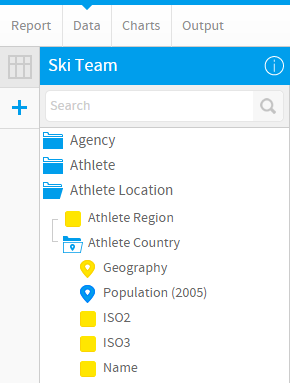
A GeoPack can be attached to a field in your view. This means that a level in the pack corresponds directly to a field in your database, and when building reports you wish to incorporate the pack data (geometry and demographic metrics) into your reports along side your own categories and metrics. | |
A GeoPack can be attached to a field in your CSV. This is the same as the above option, but you are attaching to a CSV field during the Report Import process, rather than a standard View Field. This means that a level in the pack corresponds directly to a field in your database, and when building reports you wish to incorporate the pack data (geometry and demographic metrics) into your reports along side your own categories and metrics. | |
A GeoPack can be used as standalone data. This means that when building a map based on your Views, you can add layers based solely on GeoPack data, without having to link the pack to your data directly. As both maps use geometry for their placement, the GeoPack Map Layer will just be laid over the top of your own data, allowing for comparisons. |
...
ジオパックをビュー内のフィールドに取り付けることができます。この場合、パック内の階層が、データベース内のフィールドに直接対応します。レポートの作成時に、パックのデータ(ジオメトリとデモグラフィックメトリック(数値))をレポートに取り込み、独自のカテゴリーやメトリック(数値)と並べて表示することができます。 | |
ジオパックをCSVで取り込んだデータのフィールドに取り付けることができます。これは上記の場合と同じですが、レポートのインポート処理の中で、標準のビューフィールドではなく、CSVフィールドに取り付ける点が異なります。この場合、パック内の階層が、データベース内のフィールドに直接対応します。レポートの作成時に、パックのデータ(ジオメトリとデモグラフィックメトリック(数値))をレポートに取り込み、独自のカテゴリーやメトリック(数値)と並べて表示することができます。 | |
ジオパックは独立したデータとして使用することができます。この場合、ビューに基づくマップを作成するときに、ジオパックのデータだけに基づいてレイヤーを追加することができます。パックをデータに直接関連付ける必要はありません。いずれのマップも配置にジオメトリが使用されるので、ジオパックのマップレイヤーが独自のデータの上に重ねられ、比較が可能になります。 |
ビューへのアタッチ
| Styleclass | ||
|---|---|---|
|
...
A GeoPack can be attached to a field in your view. This means that a level in the pack corresponds directly to a field in your database, and when building reports you wish to incorporate the pack data (geometry and demographic metrics) into your reports along side your own categories and metrics.
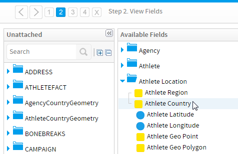
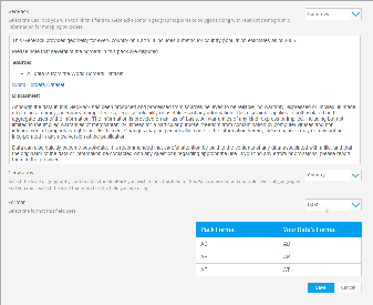
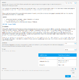
ビュー内のデータを、ロードされているジオパックに関連付ける手順を以下に示します。The following steps will walk you through linking data in your view to a loaded GeoPack:
| Section | ||||||||||
|---|---|---|---|---|---|---|---|---|---|---|
|
| Section | ||||||||||
|---|---|---|---|---|---|---|---|---|---|---|
|
| Section | ||||||||||
|---|---|---|---|---|---|---|---|---|---|---|
|
| Section | ||||||||||
|---|---|---|---|---|---|---|---|---|---|---|
|
| Section | ||||||||||
|---|---|---|---|---|---|---|---|---|---|---|
|
| Section | ||||||||||
|---|---|---|---|---|---|---|---|---|---|---|
|
| Section | ||||||||||
|---|---|---|---|---|---|---|---|---|---|---|
|
| Section | ||||||||||
|---|---|---|---|---|---|---|---|---|---|---|
|
| Section | ||||||||||
|---|---|---|---|---|---|---|---|---|---|---|
|
...
CSVにアタッチ
| Styleclass | ||
|---|---|---|
|
...
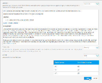
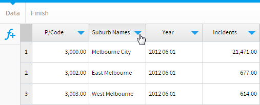
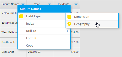
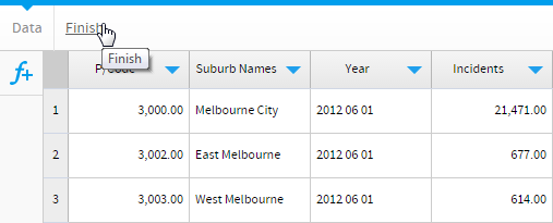
CSV内のデータを、ロードされているジオパックに関連付ける手順を以下に示します。
| Section | ||||||||||
|---|---|---|---|---|---|---|---|---|---|---|
|
| Section | ||||||||||
|---|---|---|---|---|---|---|---|---|---|---|
|
| Section | ||||||||||
|---|---|---|---|---|---|---|---|---|---|---|
|

| Section | ||||||||||
|---|---|---|---|---|---|---|---|---|---|---|
|
| Section | ||||||||||
|---|---|---|---|---|---|---|---|---|---|---|
|
| Section | ||||||||||
|---|---|---|---|---|---|---|---|---|---|---|
|

| Section | ||||||||||
|---|---|---|---|---|---|---|---|---|---|---|
|
| Section | ||||||||||
|---|---|---|---|---|---|---|---|---|---|---|
|
独立したマップレイヤー
| Styleclass | ||
|---|---|---|
| ||
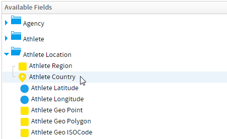
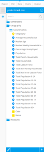
ビューやCSVでジオパックを関連付けずにマップレイヤーを作成する手順を以下に示します。
| Section | ||||||||||
|---|---|---|---|---|---|---|---|---|---|---|
|
| Section | ||||||||||
|---|---|---|---|---|---|---|---|---|---|---|
|
| Section | ||||||||||
|---|---|---|---|---|---|---|---|---|---|---|
|
...
A GeoPack can be attached to a field in your CSV. This is the same as the above option, but you are attaching to a CSV field during the Report Import process, rather than a standard View Field. This means that a level in the pack corresponds directly to a field in your database, and when building reports you wish to incorporate the pack data (geometry and demographic metrics) into your reports along side your own categories and metrics.
The following steps will walk you through linking data in your CSV to a loaded GeoPack:
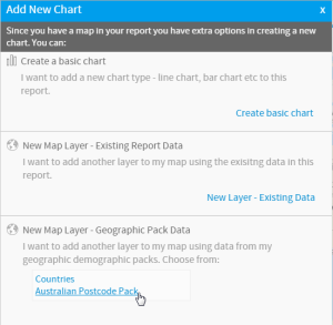
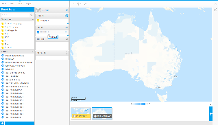
Standalone Map Layer
| Styleclass | ||
|---|---|---|
| ||
A GeoPack can be used as standalone data. This means that when building a map based on your Views, you can add layers based solely on GeoPack data, without having to link the pack to your data directly. As both maps use geometry for their placement, the GeoPack Map Layer will just be laid over the top of your own data, allowing for comparisons.
The following steps will walk you through creating a Map Layer without having to link a GeoPack in the View/CSV:
| horizontalrule |
|---|
| Styleclass | ||
|---|---|---|
|
...