Page History
...
| Table of Contents | ||
|---|---|---|
|
...
概要
| Styleclass | ||
|---|---|---|
| ||
The raster maps can be used for any type of location reporting not just ‘geographic’ maps. For example you could use these for:
- Floor Plans
- Car Body Parts
- Network Maps
- Country Maps
...
ラスターマップは「地理的な」マップとしてだけでなく、どのような種類のロケーションレポートでも利用できます。たとえば以下のようなものがあります。
- フロアプラン
- 自動車のボディパーツ
- ネットワークマップ
- カントリーマップ
マップの仕組み
| Styleclass | ||
|---|---|---|
| ||
...
ラスターマップの読み込み
| Styleclass | ||
|---|---|---|
| ||
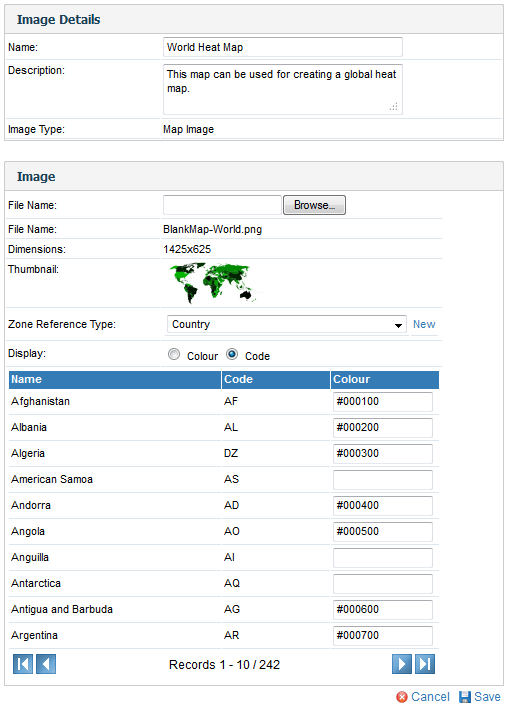
- To load a Raster Map Image, ensure that your image has unique colour for every region required.
- Ensure that you have reference code setup for your map data. E.g. For the example in Yellowfin you have a country reference code defined by ISO code. These ISO codes will be linked to each zone.
- Similar to loading an image click the add link, provide a name and select map type.
- You will now see a Map details section. For a basic Map you can leave the reference type as None.
- In the layer section you will have to load the actual image you want to use. Maps support multiple layers for the same map. For example you could have a layer for country or region which uses the same world outline.
- On the layer choose the name and description for the image layer that you are loading
- Browse and upload the map you want to load.
- Choose layer as the layer type.
- Choose the zone reference type. This is used to link the zones to specific reference code values.
- For each colour select the appropriate reference code value.
- Click Save to save your Raster map.
- ラスターマップを読み込む際には、必要な区域にユニークな色が設定されていることを確認してください。
- また、マップデータ用の参照コードが設定されていることも確認してください。たとえば、国名コードを基に国名の参照コードを設定するなどです。これらの国名コードは、各区域にリンクされます。
- イメージの読み込みと同様「追加」をクリックして、マップの名前を入力し、マップの種類を選択します。
- 「マップ詳細」セクションが表示されます。基本のマップの場合、参照タイプが「何もなし(None)」でもかまいません。
- 「レイヤー」セクションでは、使用したい実際のイメージを読み込む必要があります。マップ機能では、1つのマップに複数のレイヤーを作成できます。たとえば、1つの世界地図に国と地方のレイヤーを持たせます。
- 読み込もうとしているイメージレイヤーの名前と説明を入力してください。
- マップを指定して、アップロードします。
- 「レイヤータイプ」に「レイヤー」を選択します。
- 「区域参照タイプ」を選択します。「区域参照タイプ」は、特定の参照コードの値とリンクするために必要です。
- 適切な参照コードの値の色を設定します。
- 「保存」をクリックして、ラスターマップを保存します。
詳細については、イメージマップチュートリアルを参照してください。See Image Map Tutorial for more information.
| horizontalrule |
|---|
| Styleclass | ||
|---|---|---|
| ||