Page History
| Anchor | ||||
|---|---|---|---|---|
|
| Table of Contents | ||
|---|---|---|
|
...
概要
| Styleclass | ||
|---|---|---|
|
...
A WMS layer is a georeferenced map image loaded from a Web Map Service. These are used as backgrounds and overlays for geographical maps in Yellowfin.
...
WMSレイヤーの読み込み
| Styleclass | ||
|---|---|---|
|
...
- WMSレイヤー(WMS Layer)を読み込むには、「管理コンソール」の「イメージとマップ」に移動します。「WMSレイヤー(WMS Layer)」イメージタイプを選択し、WMSサーバーのサーバー詳細を入力します。「
 レイヤーのロード」をクリックして、サーバーのすべてのWMSレイヤーを表示します。
 - レイヤーの一覧が表示されます。レイヤーの横のチェックボックスをオンにして、「プレビュー」または「保存」をクリックすると、それらをプレビューまたは保存することができます。
- 保存すると、「イメージとマップ」にWMSレイヤー(WMS Layer)が表示されます。
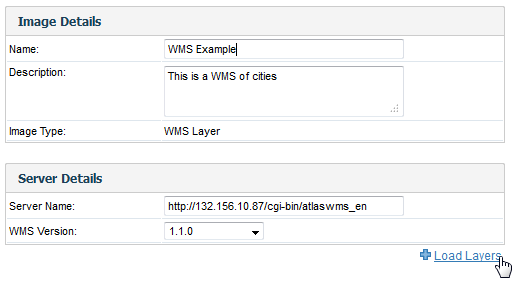
- To load a WMS Layer go to the Images and Maps link in Administration. Select the WMS Layer image type and enter the server details as per your WMS server. Click the Load Layers link to view all the WMS layers on the server.
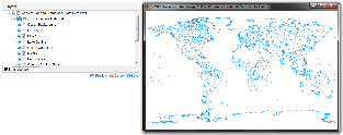
- You should now have a list of layers that you can preview and save by selecting the checkbox next to a layer and then clicking the Preview and Save links.
- Once saved, you should then see the WMS layer listed on your Images and Maps list.
| horizontalrule |
|---|
| Styleclass | ||
|---|---|---|
|
...