Page History
...
| Table of Contents | ||
|---|---|---|
|
...
概要
| Styleclass | ||
|---|---|---|
| ||
A WMS layer is a georeferenced map image loaded from a Web Map Service. These are used as backgrounds and overlays for geographical maps in Yellowfin.
...
WMSレイヤー(WMS Layer)は、Web Map Serviceから読み込まれたジオリファレンスマップイメージです。Yellowfinの地図の背景やオーバーレイとして使用されます。
WMSレイヤーの読み込み
| Styleclass | ||
|---|---|---|
| ||
- To load a WMS Layer go to the Images and Maps link in Administration. Select the WMS Layer image type and enter the server details as per your WMS server. Click the
 Load Layers link to view all the WMS layers on the server.
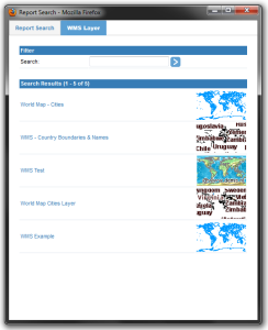
 - You should now have a list of layers that you can preview and save by selecting the checkbox next to a layer and then clicking the Preview and Save links.
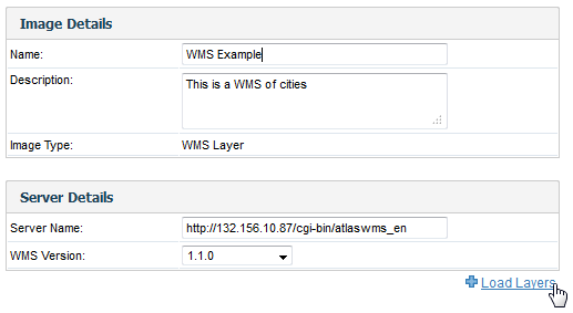
- Once saved, you should then see the WMS layer listed on your Images and Maps list.
...
- WMSレイヤー(WMS Layer)を読み込むには、「管理」の「イメージとマップ」に移動します。「WMSレイヤー(WMS Layer)」イメージタイプを選択し、WMSサーバーのサーバー詳細を入力します。 「レイヤーのロード」をクリックして、サーバーのすべてのWMSレイヤーを表示します。
- レイヤーの一覧が表示されます。レイヤーの横のチェックボックスをオンにして、「プレビュー」または「保存」をクリックすると、それらをプレビューまたは保存できます。
- 保存すると、「イメージとマップ」にWMSレイヤー(WMS Layer)が表示されます。
WMSレイヤーの追加
| Styleclass | ||
|---|---|---|
| ||
- グラフビルダーを使ってGISマップを作成した場合は、「グラフデータ」セクションの下部にある 「レイヤーの追加」をクリックします。
- 「レイヤー」ポップアップウインドウが表示されます。このウインドウでWMSレイヤーを選択し、「追加」をクリックします。
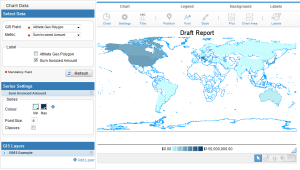
- レポートに、下の図に示すようなWMSレイヤー(WMS Layer)が追加されています。
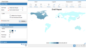
- When you have created a GIS map using the chart builder, click on the Add Layer link at the bottom of the Chart Data section.
- You will then see the Layer popup window, from which you can select your WMS Layer and click Add.
- Your report should now have a WMS Layer added, like the one pictured below.
| horizontalrule |
|---|
| Styleclass | ||
|---|---|---|
| ||