Page History
...
| Styleclass | ||
|---|---|---|
| ||
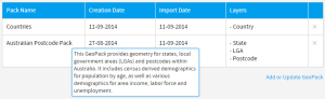
In order to incorporate GeoPack data into your reports and maps, you will need to obtain a pack, and import it into the system. These steps are outlined below.
Once these are complete, you will be able to use your pack data through one of three methods. See GeoPack Use for more information.
Obtain
| Styleclass | ||
|---|---|---|
| ||
...
| Section | ||||||||||
|---|---|---|---|---|---|---|---|---|---|---|
|
Now that your pack is uploaded you will be able to make use of it in your reports and maps. See GeoPack Use for more information.
Update
| Styleclass | ||
|---|---|---|
| ||
...